")
")


SEISMIC HAZARD AND RISK IN SICILY
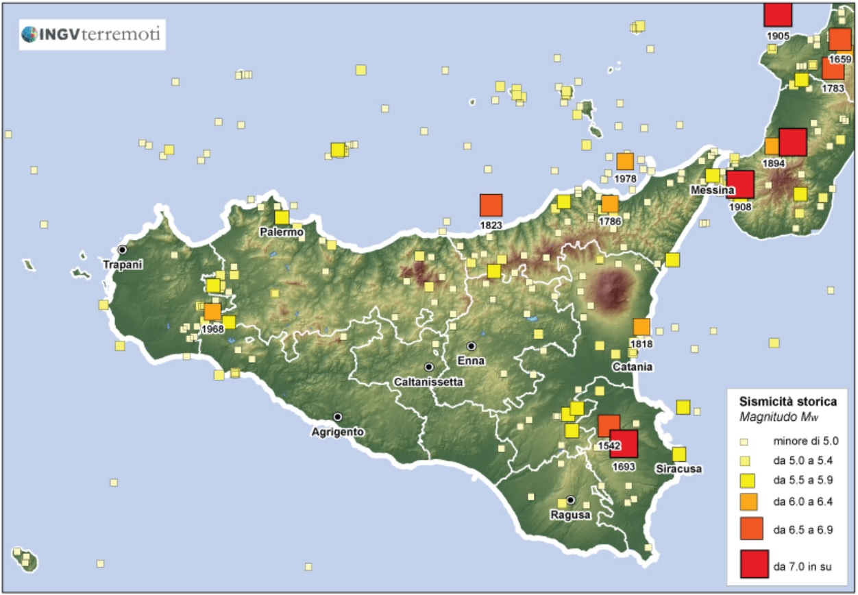
Historically, Sicily has suffered numerous catastrophic earthquakes (M ≥7), undoubtedly among the largest in Italy also in terms of number of victims. The events of 1693 in Val di Noto or the 1908 Messina earthquake are certainly the best known and affected the entire eastern sector of Sicily, but the western part of the region was also strongly marked by the destructive effects of the 1968 quakes in Valle del Belice (Tab. 1). However, there are numerous so-called "minor earthquakes" (M5-6) that widely affect the entire Sicilian territory, but are equally capable of producing serious damage and localized destruction. The 1990 S. Lucia earthquake in the Syracuse area, the 1993 Pollina (Madonie) earthquake and the 2002 Palermo earthquake are the most recent examples, in addition to the numerous seismic swarms and volcano-tectonic earthquakes that occur on Etna. The most recent of these is the 26 December 2018 earthquake (M4.9), which damaged the area between Fleri and Pisano heavily, with more than 1,100 people in the area left homeless.
Tab. 1 - Main earthquakes occurring in Sicily from the year 1000 to the present, taken from the Parametric Catalogue of Italian Earthquakes CPTI15 (Rovida et al., 2016). However, some events outside the region also have a strong impact on Sicily.
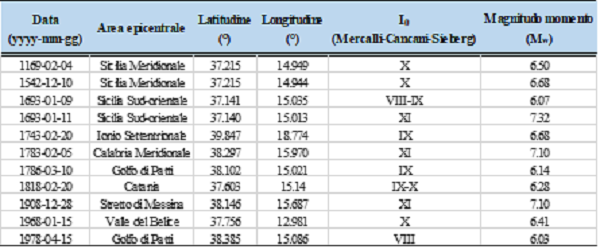
The high seismic hazard of the Sicilian regional territory is the result of a very active geodynamic process at the Central Mediterranean scale, which determines significant seismic releases along the northern and eastern edges of the island, and in the frontal submerged sectors, where, moreover, tidal waves can be generated as documented historically. The recent instrumental seismicity, although clearly highlighting some of the main Sicilian seismic areas (Fig. 1), does not allow a complete characterization of the seismogenic structures hypothesized by the studies of historical seismology and archaeo-seismology, or by those of active tectonics.
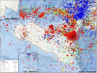
Fig. 1- Instrumental seismicity from 1985 to 2018, represented by depth classes (colour) and magnitude (size of circles). The squares show the epicentres of the main historical events.
The sources of the strong earthquakes that struck Sicily have not yet been unequivocally identified, however the catalogue of seismogenic sources in Italy (Database of Individual Seismogenic Sources, DISS Working Group, 2018), based on geological, seismological and geophysical evidence, has identified numerous structures capable of producing earthquakes of magnitude greater than 5.5. Figure 2 shows the results for Sicily, distinguishing between Individual Sources, which do not necessarily represent all potentially existing sources - because the earthquakes for which they were derived are a subset of all earthquakes - and Composite Sources, which represent a homogeneous set of possible seismogenic sources. Finally, the DISS also includes Debated (or Uncertain) Sources, i.e. areas around active faults proposed in the literature as potentially seismogenic sources, but for which there are conflicting opinions.
Fig. 2 - Map of potentially active seismogenic sources in Sicily and surrounding areas (Database of Individual Seismogenic Sources, DISS 3.2.1).
As shown by the current National Seismic Hazard Map (Fig. 3) (MPS, http://zonesismiche.mi.ingv.it), Sicily is, therefore, a region with a high hazard, where it is important to acquire more in-depth knowledge of the territory and of the seismic phenomena occurring here, both through a continuous and extended multi-parameter monitoring, and through analyses aimed at a better characterisation, at local scale, of the factors determining it.
This situation leads to high seismic risk due to the presence of a generally vulnerable building heritage, which in large metropolitan urban areas has extremely relevant implications (Palermo, Catania and Messina first and foremost). On the island the risk is also exacerbated by the existence of important industrial poles, essentially petrochemicals, in various areas of the island (Syracuse, Milazzo, Gela, Porto Empedocle).
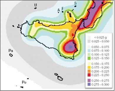
Fig. 3 - Detail of the seismic hazard map for the Sicily region (from MPS Working Group, 2004). Note that the entire eastern sector of the island is exposed to significant shaking values (maximum expected acceleration, PGA).
In Italy, risk assessments at national level have always been based on the only available data for the entire residential building heritage, represented by the censuses carried out by the National Institute of Statistics (ISTAT). These data, although extremely poor in information content, have allowed a characterisation of the seismic vulnerability of buildings and, together with hazard studies, to produce the first national seismic risk maps.
Recently, the IRMA platform (Italian Risk MAps, Borzi et al. 2018), described in Dolce et al., 2019, has been developed. It is a sharing web environment using OpenQuake (developed by the GEM Foundation) as a calculation engine, and in which the results and contributions of each seismic risk research group have been pooled together. IRMA refers to the MPS04 hazard model (Stucchi et al. 2004, 2011), adopted at a national level with the decree of the President of the Council of Ministers 3519/2006 and implemented in 2008 by the New Technical Standards for Construction (D.M.14.01.2008).
Since 2009, the DPC has been developing a new set of tools for seismic risk assessment with the support of the EUCENTRE Foundation, allowing to create new risk maps for the national territory shared by the scientific community. The results of the project, coordinated by the DPC, provided the basis for the contents of SICURO+ (Sistema Informativo di ComUnicazione del RischiO_ IT system of Risk Communication, https://www.sicuropiu.it): a probabilistic assessment of the material, economic and functional consequences (damage) that may be caused by earthquakes in a given place and time interval. The web platform hosts a tool that interacts with the citizen in stages. It is designed to enable use also by users without special computer knowledge or technical-scientific training in the seismic field.
A dossier drawn up a few years ago by the National Seismic Service estimated that, by simulating some strong earthquakes of the past (such as 1693 or 1908), there could be more than 400,000 victims and/or injured, with more than 300,000 homeless in the 10 sample cities considered alone. The factors applied in this calculation, catalogued in the Civil Protection's SIGE (Sistema Informatico di Gestione delle Emergenze - Emergency Management Information System), are various: in addition to population density, there is the vulnerability of the buildings, defined according to age and construction materials (Fig. 4), the height of the buildings and the type of foundation soil. On the basis of these elements, the so-called 'damage scenarios' were generated: Catania would be the most affected city, with as many as 160,000 dead and injured and 136,000 homeless; Messina would have 110,000 physically affected citizens and 95,000 displaced; Syracuse would have over 60,000 dead and injured and 49,000 homeless. The impact on Ragusa (32,000 and 27,000), Vittoria (26,000 and 22,000), Noto (10,000 and 8,000) and Augusta (16,000 and 13,000) is also worrying.
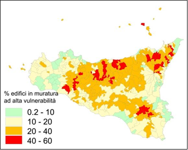
Fig. 4 - Example of territorial distribution of the vulnerability of masonry buildings (source: Edurisk-INGV project).