")
")


The OSU Project (Urban Seismic Observatory - City of Catania)
The vulnerability of Catania's architectural heritage together with the high population density (exposure) rank the city among those at highest seismic risk in the whole of Italy. In addition, its historical centre, rebuilt after the 1693 earthquake, is a unique case in the world, representing an important testimony of late Baroque art and architecture.
Over the last 1000 years, Catania has been struck several times by destructive earthquakes, such as the events of 1169 and 1693, and severely damaged by other seismic events (e.g. in 1542 or 1818). The 1693 earthquake is one of the largest catastrophic events to have affected eastern Sicily. Following the reconstruction, Catania's historic centre now contains a valuable cultural and artistic heritage, and was included in the 2002 UNESCO World Heritage List, joining the previously recognized cities of the well-known 'Val di Noto'.
The impact of a strong earthquake on an urban community can be reduced with timely and well-planned actions by Civil Protection structures. In this perspective, it is fundamental that the organizations in charge of seismic monitoring of the national territory are equipped with precise observation tools that can provide useful information for the optimal management of emergencies in the immediate post-earthquake period.
In recent decades, in different parts of the world, mainly in areas prone to large earthquakes (e.g. Japan, California, Sumatra, etc.), urban seismic networks (OSUs - Urban Seismic Observatories) and Earthquake Early Warning (EEW) systems have been developed/implemented to ensure continuous monitoring and real-time processing of the information collected, allowing the distribution of shaking intensity following an earthquake to be provided in a timely manner to emergency management centres. Real-time quake maps could enable emergency management bodies to manage priorities and allocate resources more effectively. In addition, checks on the degree of damage and suitability to access or use buildings could be carried out according to a priority logic based on the maximum shaking measured by the urban seismic network.
In 2017, the idea of realizing a prototype of a Smart integrated seismic-accelerometric monitoring system in the historical centre of the city of Catania (Urban Seismic Observatory) took shape. This was confirmed with the signing of an agreement between the Etnean Observatory of the National Institute of Geophysics and Volcanology, the Engineering Department of the University of Catania and the Municipality of Catania, under the supervision of Domenico Patanè, Research Manager of INGV.
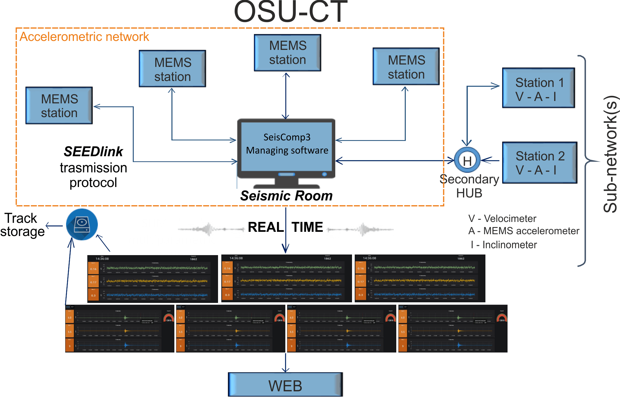
Block diagram of the data acquisition, transmission, storage and display system.
At the end of 2017, a project called eWAS "an early WArning System for cultural heritage", was presented within the frame of the specialist "Cultural Heritage" field in the call for bids issued by MIUR "Notice for the submission of industrial research and experimental development projects in the 12 Areas of Specialisation identified by the National Research Programme 2015-2020". The project leader is the INGV together with the Municipality of Catania, the University of Catania, the University of Enna "KORE" and several SMEs (Meridionale Impianti S.p.a., TME S.r.l., Etna Hitech S.c.p.a., N.T.E.T. Spa, Laboratori & Ricerche S.r.l., Ingegneria Costruzioni Colombrita S.r.l.).
In 2018, a first phase of activities began within the framework of the agreement, leading to the installation of a first nucleus of prototype stations set up within INGV, equipped only with MEMS accelerometer, whose signals were acquired for a short period at the Osservatorio Etneo (Patanè et al., 2018).
During 2018, MIUR approved and funded the eWAS project, the top in rankings of funded projects, with INGV as lead partner and the Municipality of Catania as a partner.
In 2019, the project activities of eWAS started and an accurate phase of study, research, analysis and technical design was initiated, leading to re-designing the acquisition systems, the choice of the sensors to be coupled (velocimeter and accelerometer) and the evaluation of the data transmission systems to be adopted.
In the first months of 2020, the first instrumentation prototypes were replaced with a new version of the Smart multi-parameter acquirer and new MEMS accelerometric sensors with lower noise (OSU-AQ1), realised in eWAS. In addition, the design and development of multi-parameter sensor nodes for Structural Health Monitoring (SHM) has been initiated, whose data will flow to a master station (OSU-AQ) that will also be equipped with a wide-band (5s) velocimeter (Fertitta et al., 2019) and an on-site Early Warning system.
In 2021, the final installation phase was started with the new OSU-AQ2 stations suitably re-engineered after the trials made with the previous prototypes (OSU-AQ1).
As part of the agreement, some 30 historic municipal and public buildings were already selected, including both important (e.g. schools, hospitals) and strategic buildings. Each of these will be equipped with at least one seismic-accelerometer station. In addition, for the buildings of Palazzo degli Elefanti (City Hall), of the University of Catania (Main Building) and of Palazzo Minoriti (Prefecture), eWAS provides structural monitoring (SHM) through a hybrid approach (static and dynamic) that allows the system to diagnose and assess the health status of the structure and its susceptibility to damage also due to issues not necessarily of seismological nature.
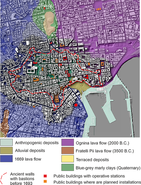
Map of the historical centre of Catania with the buildings where OSU-CT stations are already operational (red) and those identified for new installations (orange)
The project will achieve four main objectives: 1) real time seismic monitoring; 2) the testing of an urban Earthquake Early Warning on-site (UEEW) system, as already operational or being tested in several countries in the world (e.g. Japan, USA, Mexico, China, Turkey, Israel, etc.); 3) rapid damage assessment (from shaking maps) in the monitored urban area; 4) structural monitoring (SHM) of historical buildings and strategic infrastructures that play a fundamental role during crisis phases, at least for those buildings where the number of monitoring nodes is adequate for the purpose.
EWAS - Publications, Works and Conference participations
- PATANE' D., TUSA G., YANG W., ASTUTI A., COSTANZA A., COLINO A., FERTITTA G., D'ANNA G., DI PRIMA S., MANGIAGLI S., MARTINO C., TORRISI O. (2022) The urban seismic observatory of Catania (Italy): a real-time seismic seismic monitoring at urban scale, Remote Sensing, in press
- COSTANZA A., FERTITTA G., D’ANNA G., YANG W., LO IACONO F., NAVARRA G., PATANE' D. (2022), A study for the identification of a calibration system for seismic sensors, Quaderni di Geofisica INGV, n. 175
- COSTANZA A., FERTITTA G., YANG W., D'ANNA G., CHIARABBA C., STRAMONDO S. (2021), PSGSQ, a new low cost and low power protable Geophysical Station "All in One". Design and test, Annals of Geophysics, Vol. 64, n.1, https://doi.org/10.4401/ag-8544
- MUSUMECI R.E., FOTI E., LI ROSI D., SANFILIPPO M., STANCANELLI L.M., SAPIENZA V., YANG W., PATANE' D. (2021), Hydraulic risk for archaeological sites: results on the case study of Villa Romana del Casale. International Journal of Disaster Risk Reduction, 64, 102509,1, 2021.
- PATANE' D., CANTARERO M., SANFILIPPO M., MUSUMECI R.E., DE BENI E. (2020), Drone monitoring of the hydraulic risk in the catchment of Villa Romana del Casale. D-SITE. Drones - Systems of Information on cultural heritage Pavia - International Conference - 24-26 June 2020
- FERTITTA G., COSTANZA A., D'ANNA G., PATANÈ D., The Earth Lab 5s (ETL3D/5s) seismic sensor. Design and test, Annals of Geophysics, 62, Doi: 10.4401/ag-7857, 2019.
- D’ALESSANDRO A., GRECO L., SCUDERO S., SIINO M., VITALE G., D’ANNA R., DI GANGI F., NICOLOSI D., PASSAFIUME G., SPECIALE S., CATANIA M., COSENZA P., FORESTA MARTIN L., PATANE D., MARTORANA R., RAO S., STRAMONDO S., Sviluppo di una stazione sismica low-cost basata su tecnologia MEMS, Quaderni di Geofisica, n. 153, ISSN 1590-2595, 2019
- PATANÈ D. MALFITANA D., MAZZAGLIA A. (2019), Dalla conoscenza all’azione. Il progetto PON eWAS: un sistema di allerta precoce per la salvaguardia del patrimonio culturale, Atti del Convegno Internazionale di Studi “Monitoring and Maintenance of Archeological areas”, Parco Archeologico del Colosseo, 20-21 Marzo 2019, Roma.
- PATANÈ D., D'ANNA G., FERTITTA G., COSTANZA A., MARTINO C., TUSA G., YANG W. (2019), La rete accelerometrica OSU-CT nel progetto eWAS, XIV Convegno Nazionale GIT – Sezione di Geoscienze e Tecnologie Informatiche, 17-19 Giugno 2019, Melfi (Pz).
- PATANÈ D. (2018), La rete accelerometrica urbana nel centro storico della città di Catania (OSU-CT). Pubblicazioni Geologia dell’Ambiente, Supplemento al n. 1/2018, ISSN 1591-5352, p. 249-257, 2018.