by Salvatore D'Amico, 2023
Ischia Seismic Scenario (QGIS plugin)
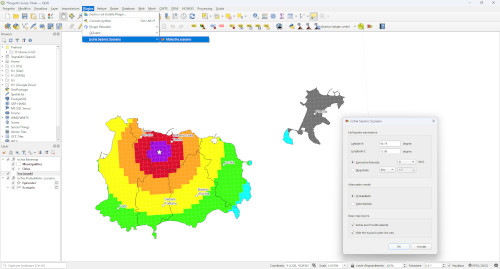
Procedure to create an intensity seismic scenario at a local scale of the island of Ischia.
This plugin allows calculating seismic scenarios expressed in terms of macroseismic intensity according to
deterministic or probabilistic models of attenuation.
The input parameters required to simulate an earthquake, are:
- epicentral location, expressed in degrees (xx.yyy);
- epicentral intensity (I0) or magnitude.
Selection of the attenuation models:
- deterministic: scenarios for epicentral intensity 6 ≤ I0 ≤ 11 (MCS);
- probabilistic: scenarios for epicentral intensity 8 ≤ I0 ≤ 11 (MCS).
This plugin is a product (supplementary material) related to the paper:
R. Azzaro, S. D'Amico, R. Rotondi, E. Varini (2023). The attenuation of macroseismic intensity in the volcanic island of Ischia (Gulf of Naples, Italy): comparison between deterministic and probabilistic models and application to seismic scenarios. Bulletin of Earthquake Engineering, doi: 10.1007/s10518-023-01724-9.
by Salvatore D'Amico, 2008
MacroMap (MapInfo plugin)
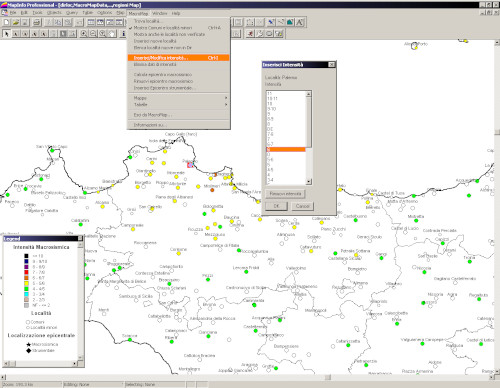
GIS-based utility for the management of macroseismic data, from the geo-referencing input to final plotting on the map.
The routine is compiled to run as a fully integrated internal application of the software MapInfo 7.0 (or higher). MacroMap was developed to meet the need for a simple and quick tool to be used in the different phases of the macroseismic study of an earthquake. The identification of the place associated with the macroseismic observation represents a routine operation that may cause errors and problems that only become apparent later, during the analysis and interpretation of data. MacroMap has been tested “in the field” during the survey of some damaging earthquakes, taking also into account the experience and suggestions of the QUEST working group (QUick Earthquake Survey Team) operating at INGV. In addition, the structure of the utility reflects the format of the geographic database (reference DIR04) and procedures adopted in compiling the Italian Macroseismic Database DBMI04. The fields of application of MacroMap extend from editing maps and tables to be attached to macroseismic reports for Civil Protection purposes, to revising historical events, thanks to the use of advanced queries to identify and select place-names from the geographic database.
This plugin is a product related to the paper:
S. D'Amico, R. Azzaro (2008).
MacroMap: una utility per MapInfo per la georeferenziazione di
dati macrosismici e la loro rappresentazione cartografica.
Quaderni di Geofisica, 55.